Geo Queries Traversal Examples
This example demonstrates how to perform a graph traversal based on a geo query. It starts by finding cities within a specified radius from a given set of coordinates (in this case, Bonn). Then, it performs a graph traversal using those cities as starting points and returns the connected cities within one edge away.
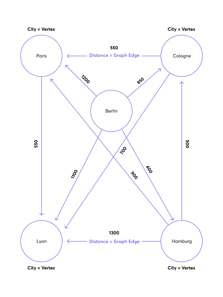
To follow along, create a new graph using the Route Planning Graph example.
Locating Start Vertex with Geo Query
This example locates the start vertex for a graph traversal using a geo index.
The query below searches for cities within a 400,000-meter radius of the provided coordinates for Bonn:
LET bonn = [50.7340, 7.0998]

FOR startCity IN WITHIN(germanCity, bonn[0], bonn[1], 400000)
  RETURN startCity
This query returns German cities within 400 km of Bonn, such as Hamburg and Cologne. It does not return Paris, as it is in the frenchCity collection.
[
    {
        "_id": "germanCity/Cologne",
        "_key": "Cologne",
        "_rev": "_fvOwSD6--C",
        "geometry": {
            "coordinates": [
                6.9528,
                50.9364
            ],
            "type": "Point"
        },
        "isCapital": false,
        "population": 1000000
    },
    {
        "_id": "germanCity/Hamburg",
        "_key": "Hamburg",
        "_rev": "_fvOwSD6--F",
        "geometry": {
            "coordinates": [
                10.0014,
                53.5653
            ],
            "type": "Point"
        },
        "isCapital": false,
        "population": 1000000
    }
]
Graph Traversal with Geo-based Start Vertices
You can execute the geo query separately, get the _id values for the start cities (Cologne and Hamburg, from the previous query), and then pass them as bind parameters to the graph traversal query:
Syntax:
FOR startCityId IN [ @city1, @city2 ]
  LET startCity = DOCUMENT(startCityId)
  FOR v, e, p IN 1..1 OUTBOUND startCity GRAPH 'routeplanner'
    RETURN { startCity: startCity._key, traversedCity: v }
Here the bind parameters are replaced by ids:
FOR startCityId IN [ "germanCity/Cologne", "germanCity/Hamburg" ]
  LET startCity = DOCUMENT(startCityId)
  FOR v, e, p IN 1..1 OUTBOUND startCity GRAPH 'routeplanner'
    RETURN { startCity: startCity._key, traversedCity: v }
The result is showing all the possible connections between the start cities and their directly connected cities in the graph:
[
    {
        "startCity": "Cologne",
        "traversedCity": {
            "_id": "frenchCity/Lyon",
            "_key": "Lyon",
            "_rev": "_fvOwSD6--I",
            "geometry": {
                "coordinates": [
                    4.84,
                    45.76
                ],
                "type": "Point"
            },
            "isCapital": false,
            "population": 80000
        }
    },
    {
        "startCity": "Cologne",
        "traversedCity": {
            "_id": "frenchCity/Paris",
            "_key": "Paris",
            "_rev": "_fvOwSD6--L",
            "geometry": {
                "coordinates": [
                    2.3508,
                    48.8567
                ],
                "type": "Point"
            },
            "isCapital": true,
            "population": 4000000
        }
    },
    {
        "startCity": "Hamburg",
        "traversedCity": {
            "_id": "germanCity/Cologne",
            "_key": "Cologne",
            "_rev": "_fvOwSD6--C",
            "geometry": {
                "coordinates": [
                    6.9528,
                    50.9364
                ],
                "type": "Point"
            },
            "isCapital": false,
            "population": 1000000
        }
    },
    {
        "startCity": "Hamburg",
        "traversedCity": {
            "_id": "frenchCity/Paris",
            "_key": "Paris",
            "_rev": "_fvOwSD6--L",
            "geometry": {
                "coordinates": [
                    2.3508,
                    48.8567
                ],
                "type": "Point"
            },
            "isCapital": true,
            "population": 4000000
        }
    },
    {
        "startCity": "Hamburg",
        "traversedCity": {
            "_id": "frenchCity/Lyon",
            "_key": "Lyon",
            "_rev": "_fvOwSD6--I",
            "geometry": {
                "coordinates": [
                    4.84,
                    45.76
                ],
                "type": "Point"
            },
            "isCapital": false,
            "population": 80000
        }
    }
]
A simpler way to consider the results is:
- Start City: Cologne
- Traversed City: Lyon
- Traversed City: Paris
- Start City: Hamburg
- Traversed City: Cologne
- Traversed City: Paris
- Traversed City: Lyon
Grouping Traversals by Start City
This example combines the previous two queries.
You can use a LET statement with a subquery to group the traversals by their startCity efficiently. This query finds cities within a 400,000-meter radius of the provided coordinates for Bonn, then uses a subquery to find connected cities for each found city within one edge away in the routeplanner graph.
LET bonn = [50.7340, 7.0998]

FOR startCity IN WITHIN(germanCity, bonn[0], bonn[1], 400000)
    LET oneCity = (
        FOR v, e, p IN 1..1 OUTBOUND startCity GRAPH 'routeplanner'
            RETURN v
    )
    RETURN { startCity: startCity._key, connectedCities: oneCity }
The query returns the direct neighbors of Cologne and Hamburg in the routeplanner graph, the same as the previous one.